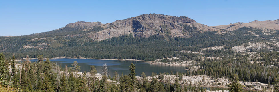
Carson Pass Nordic Skiing and Snowshoeing
Carson Pass becomes a cross-country skier's and snowshoer's paradise as soon as the first twelve inches of winter snow cover the ground. Locations above 4,000 feet usually have plenty of snow once winter arrives.
On the west side of the pass you cross the 4,000-foot mark about 7 miles east of Pioneer. On the east side of the pass, the Hope Valley area, at 7,000 feet, almost always has plenty of snow.
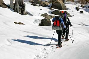
Good cross-country ski routes can be found almost anywhere. Old logging roads often make safe and easy-to-follow trails off the highway. Up in the high country, avalanche danger is a concern. There are many safe areas, though, such as Hope Valley and where there are broad meadows stretching for miles.
For cross-country ski or snowshoe rentals, groomed trails, and instruction see
Kirkwood Cross Country Center.
Carson Pass Sno-Parks
Sno-Parks make excellent locations for beginning cross-country ski trips because they are usually located adjacent to desirable back country trails. Sno-Parks have two big advantages over other pull-out spots along the highway - toilets and parking.
Sno-Parks are parking areas maintained in the winter to allow people to park safely and pursue winter activities such as cross-county skiing or snowmobiling. They have pit toilets available. To use a Sno-Park you must have a permit. You can purchase a day permit for $15 or an annual pass (Nov. 1 - May 30) for $40. They are good at any California, Oregon, Washington, or Idaho Sno-Park.
In Amador and Alpine counties passes can be purchased at the following places:
- Amador Station, 27846 Inspiration Dr., Pioneer
- Desolation Hotel, 14255 Highway 88, Hope Valley
For a complete list of locations that sell Sno-Park permits in California, see
California Sno-Park Vendors
Permits may also be purchased online for an additional $1.95 at
Sno-Park Permits.
Carson Pass Sno-Park Locations
Iron Mountain Sno-Park: Located at the junction of Mormon-Emigrant Trail Road and Highway 88. Restrooms. Recommended activities there
include cross-country skiing, dog sledding, snowmobiling, and snow play.
Meiss Meadow Sno-Park: Located one mile west of the summit of Carson Pass. Restrooms. Recommended activities there include cross-country skiing, dog sledding, and snow play. Snowmobiling is not allowed there.
Carson Pass Sno-Park: Located at the summit of Carson Pass. Restrooms. Recommended activities there include cross-country skiing, dog sledding, and snow play. Snowmobiles are not allowed there.
Hope Valley Sno-Park: Located at on Blue Lakes Road close to Highway 88. Restrooms. Recommended activities there include cross-country skiing, dog sledding, and snowmobiling. The flat terrain there is fine for making snowmen but
not for sledding.
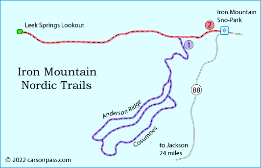
Iron Mountain Nordic Ski Trails
1. Anderson Ridge Trail System
Starting Location: Iron Mountain Sno-Park
Distance: 8 miles of trail
Elevation Range: 7,300 feet to 6,900 feet
Difficulty: Easy - Intermediate
The Anderson Ridge trails pass over rolling terrain. The trails are well marked with blue diamonds and
wooden signs. Cross-country skiers, snowshoers, and snowmobilers share the area.
2. Leek Springs Trail
Starting Location: Iron Mountain Sno-Park
Distance: 8-mile round trip
Elevation Range: 7,300 feet to 7,600 feet
Difficulty: Intermediate
Share the beginning of the trail with snowmobilers who do a good job of grooming the route. The 8-mile round trip trail follows Plummer Ridge over gently rolling terrain to the Leek Springs Lookout. The trail is marked with orange and blue diamonds. Views from the lookout can be spectacular on clear days.
Carson Pass Nordic Ski Trails
3. Woods Lake Trail
Starting Location: Meiss Sno-Park
Distance: 2 miles one way
Elevation Changes: 8,200 feet to 8,600 feet
Difficulty: Easy
The trail is an enjoyable two-mile, downhill ski to Woods Lake following the Woods Lake Road. The trail is marked, beginning across the highway from the Sno-Park, with blue diamond markers on trees. Woods Lake is frozen and covered with snow during the winter. Do not trust the ice to support your weight. It is not recommended to ski or otherwise go out on any frozen lake!
4. Wilderness Boundary Trail
Starting Location: Carson Pass Sno-Park
Distance: 2 miles one way
Elevation Changes: 8,200 feet to 8,600 feet
Difficulty: Moderate
The trail travels south to the Mokelumne Wilderness boundary, then runs west along the boundary before dropping downhill to intersect the Woods Lake Road. The trail also runs south from Woods Lake Road and travels up the drainage between Woods Lake and Winnemucca Lake. It stops at the Wilderness boundary. Blue diamond markers attached to tress identifies this trail.
5. Meiss Meadow Area
Starting Location: Meiss Sno-Park
Distance: 4 miles one way
Elevation Changes: 8,200 feet to 8,900 feet
Difficulty: Difficult - for experienced back country skiers
This route is unmarked. The route generally follows the Pacific Crest Trail north from the Sno-Park 2.5 miles, and then swings directly north and down into Meiss Meadows. Make a loop around Meiss Lake (do not go on lake - very dangerous even if ice looks solid) and return by same route.
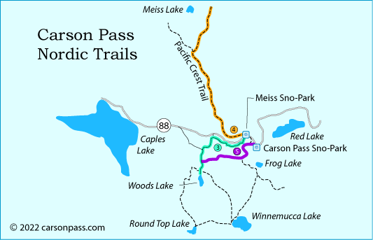
6. Mokelumne Wilderness Area
Starting Location: Carson Pass Sno-Park
Distance: 2 - 20 miles one way
Elevation Changes: 8,200 feet to 9,800 feet
Difficulty: Moderate to Difficult - for experienced back country skiers
Unmarked route into the Mokelumne Wilderness. This area is for experienced back country travelers who can assess avalanche danger and find their own route. The Forest Service recommends this area for those who "possess advanced mountaineering skills." Explore on your own to the extent your personal skills allow. Mokelumne Wilderness offers skiing through forested mountainsides, around alpine lakes, and over open timberline landscapes as well as opportunities for very challenging downhill terrain. Overnight camping permit is required.
Back Country Safety
- Check with the Forest Service or ski patrol before heading out to be sure conditions are safe on the route you will be using.
- Always carry emergency supplies, an emergency locator device, and a fully charged cell phone.
- Let a responsible person know where you are going and when you will be returning.
- Travel with at least one other person.
The Sierra Avalanche Center provides information about avalanche conditions in the Sierra from Yuba Pass in the north to Ebbetts Pass in the south. Visit their website at Sierra Avalanche Center.
The Humboldt-Toiyabe National Forest Bridgeport Winter Recreation Area was designed mostly for snowmobilers, but the safety information and links are valuable for cross country skiers and snowshoers as well.
Eldorado Backcountry Ski Patrol
The Eldorado Backcountry Ski Patrol is a volunteer ski patrol working in the Eldorado National Forest.
The Patrol serves snowshoers and cross country skiers as needed with emergency first aid, information, maps, trail marking and maintenance, and assistance to other emergency responders. They offer classes in winter backcountry skills such as map and compass and avalanche awareness. They also lead backcountry tours.
Eldorado Backcountry Ski Patrol
Kirkwood Cross Country Center
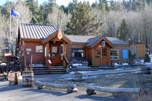
Kirkwood's Cross Country Center offers 80 km of groomed trails for cross-country skiing. They have both skating and snowshoeing lanes on three interconnected trails systems, along with two trailhead facilities. They are located on Highway 88, one quarter mile east of the entrance to Kirkwood. Look for the Kirkwood Inn. The Cross Country Center is next door.
(209) 258-7248
Kirkwood's Cross Country Center While on the Kirkwood Cross Country Center website, click on their XC Trail map for a view of their groomed trail system.
Facilities also include warming huts, a Kiddy Kilometer with animal cut-outs and flip up signs, a day lodge, and equipment rentals.
Other Sierra Passes - Other Cross Country Adventures
Ebbetts Pass
Cross country skiing and snow shoeing around Ebbetts Pass Scenic Byway (Highway 4) can be spectacular. Use Bear Valley as a base and set out for Lake Alpine or along trails to Spicer Meadow Reservoir. Bear Valley Cross Country has rentals and groomed trails complete with warming huts. Learn about it all at Ebbetts Pass Adventures.
Echo Summit
A short distance to the north, Echo Summit (Highway 50) has miles of great cross country and snowshoe routes. From Echo Summit to Loon Lake, cross country skiers will find trails to match every ability. See maps and read about them on
Discover Echo Summit.
Sonora Pass
Sonora Pass (Highway 108) offers wonderful cross country skiing and snow shoeing, especially around Pinecrest Lake and Dodge Ridge. Find more information at Sonora Pass Vacations.